Our outage map is updated every 15 minutes and includes information on where an outage has occurred, approximately how many customers are affected, the status of our crews, the cause (if known), and the estimated time we expect to have power restored by.
To see the latest information about the outage in your area, click the icon on the map that is closest in proximity to your address.
Areas highlighted in grey, represented with a 'wrench' icon, are known planned outages that identify where crews have been scheduled to perform maintenance work to our infrastructure.
View the Outage MapThis map does not include momentary outages, also known as ‘auto-reclosures.’ This is when a Hydro Ottawa circuit breaker opens momentarily to allow a temporary fault or problem on the distribution system to clear (e.g. lightning strike or tree branch contact).
Unconfirmed outages also appear on the map as pending classification. These are areas that we have identified as possibly being without power, but have yet to confirm.
If your outage is not on our map, make sure to report it, in order for us to have it in our systems and send a crew out. You can report an outage on our website, through our mobile app, or by calling our 24/7 outage line at 613- 738-0188.
Learn how we prioritize and restore power outages.
Frequently Asked Questions
You can report an outage on our website, through our mobile app, or by calling our 24/7 outage line at 613-738-0188.
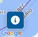
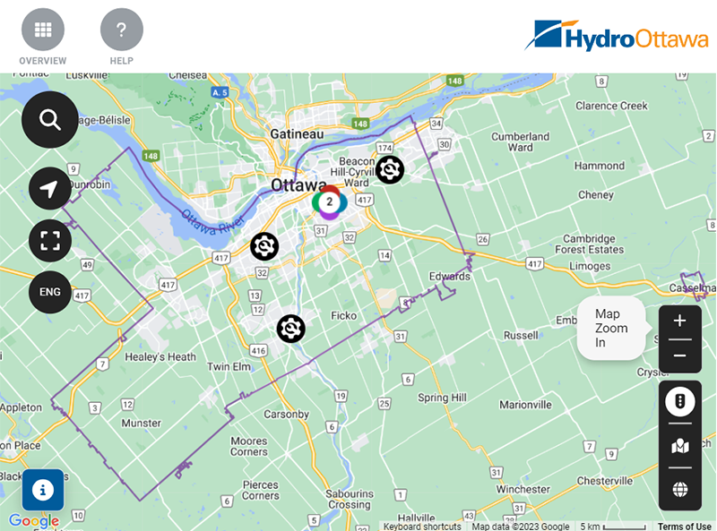
The map defaults to a view of our entire service territory and uses icons to identify where outages are happening and how many customers are affected. To view the map legend and to see what the icons on the map mean, click on the ‘i symbol’ near the bottom left of the map.
In the map legend, you can click on the ‘View by location’ button and have the option to view the map by city ward, or by neighbourhood.
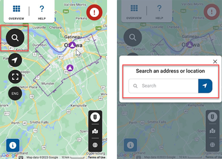
The magnifying glass icon acts as a search function and is located near the top left of the map. When you enter your street address, the map will zoom in to your area.
You can save your location for future reference by clicking on the locator button. A tab will open on the right side of the screen. You will have the option to add a nickname for the location, such as ‘home’ or ‘work’. Click ‘Save to Bookmark’. You can edit or delete at any time.
The outage map updates every 15 minutes, so if the outage has just occurred, it may not appear on the map right away. You should still report the outage to be certain we are made aware of your area. You can report an outage on our website, through our mobile app, or by calling our 24/7 outage line at 613-738-0188.
When you click on the outage icon you are interested in, a tab will appear on the right side of the screen providing details such as the time the outage started, how many customers are affected, the estimated time of restoration, and cause, if known.
If there are multiple outages in an area, you will see a multi-coloured icon with a number inside it. By clicking on this icon, you will see a breakdown of individual outages.
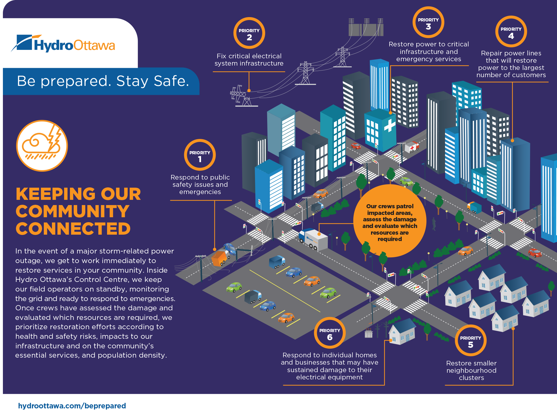
We prioritize restoration efforts according to health and safety risks, impacts to our infrastructure, essential services and population density. You can learn more about our process here.
When an outage occurs in your area, we state the status of our crews on our map. Here’s a breakdown of each status and what they mean:
Under investigation/Pending assignment: This can mean either a) a crew hasn’t been assigned to this outage yet as we are prioritizing other restoration work, or b) it is under investigation to assess the damage and evaluate which resources are required. Please continue to check back.
Crew assigned: A crew has been assigned to the area and the outage is on their list to address next.
Work in progress: A crew is actively working to restore the outage.
Changed from crew assigned to under investigation/pending assignment: This may happen if additional damage is found and different equipment, more resources or safety permits are required, or the crew has to wait until the site is safe to access. Above all, public and personal safety are the priority for our crews.
While we do our best to predict when power will be restored, estimated restoration times can change once crews get on site and assess the damage. Initial restoration times on our outage map are based on a number of factors: weather conditions, location of the outage, suspected severity of damage, past outages in the area, and more.
Once crews are able to assess the damage and identify any potential safety issues that may impact restorations, we update the estimated restoration time accordingly.
The electricity system is complex and electricity itself is very dangerous. Therefore, it is important to remember that restoration times are always estimated and never guaranteed.
The outage map default is ‘road view’ but you also have the option to view the map by satellite or a hybrid view of both. Near the bottom right of the screen you will see a box with three icons. You can toggle between these icons to see different ways the map can be displayed.
Here is a list of the most common causes of outages. Every outage presents an opportunity to learn, and will influence our future planning and storm hardening practices. Every time the power goes out, we keep a record of when and why it happened, how we resolved the outage and how long it took us to make the repairs. This information is used to identify trends for planning and prioritizing upgrades to our electricity infrastructure. It also informs our ongoing maintenance, construction projects and tree trimming programs.